i love volcanoes and lava flows. there is something abut their sheer destructive power that just fascinates me. plus the colour red. and how relentlessly it flows. and how it transforms the landscape. and how it gives birth to new life and new land. love it. i can watch this for hours transfixed.
A daily dose of odds and sods, some interesting, some bizarre, some funny, some thought provoking items which I have stumbled across the web. All to be taken with a grain of daily salt!!
Monday, October 20
Thursday, May 8
The Atlas Blaeu-Van der Hem
Kids
I saw this atlas long time back at the British library where it was on loan.
It's a massive tome. At the time this was made, you've got to remember that the books weren't printed in colour that easily so these were made by hand. 600 maps kids. By hand. Painted. Imagine doing such kind of painting with very very fine brushes, sometimes containing only a few hairs.
These were meant for royalty. And the royals would commission these books for posterity. Like they would commission a painting or sculpture.
Fine fine work. And it would open up vistas across the world. These royals will look at the maps and want to send out their people in embassies to go visit and trade and colonise. Maps are powerful things kids. Do you know that many governments still control maps? Or they force google not to show some maps of military bases or private land? It's location information. And so it's expensive.
Cartography is a fascinating subject. Remember the map we got didu? That's almost 200 years old. She loved it. She is after all a professor of geography but you two also should realise the importance of geography and cartography. It's beautifully illustrated for Diya and it's all about politics, philosophy and economics for Kannu.
Very interesting. See the images. And these were imagined just a few hundred years back. Lest you find this funny, remember the Malaysian airline which was lost in the South Indian Ocean? A searcher said that there are locations on the earth which are literally unknown. We know more about the surface of the moon and mars than earth. Go figure.
Love
Baba
The Atlas Blaeu-Van der Hem - Medievalists.net
http://www.medievalists.net/2014/03/23/atlas-blaeu-van-der-hem/
This documentary takes a look at the Atlas Blaeu-Van der Hem – one of the largest and greatest atlases ever assembled. Created by Willem Blaeu and his son Joan in 17th century Amsterdam, the atlas contains nearly 600 maps charting the world. It was published in different languages – Latin, German, French, Spanish and Dutch.
This documentary also shows how publishers created a facsimile of the historical eight-volume Atlas in the Austrian National Library.
Tuesday, March 18
The lost pages of ‘Longitude’
Kannu
We have the book. And we went to see the clocks as well at the Greenwich museum. Harrison was a brilliant man son. We also have the clockmakers museum in the guildhall in london. Small museum. Just about 2 rooms. But then you don't need that many rooms to show tiny watches and clocks. We also saw a large clock in the Salisbury cathedral if you remember? I've also seen large sun dials son, in India and elsewhere.
Time is a funny old thing. Did you know Indian mythology has the longest unit of time? Called as Kalpa? 4.3 billion years. It's mentioned in the Mahabharata and the Vishnu Purana. Both books are at home but perhaps you don't want to read the Bhagwat Purana at the moment. It's more than 1000 pagers. Fascinating book. Can you imagine the imagination of the old chaps who could imagine the concept of such a long period of time? Reach deep into the concept of time and it becomes indistinguishable with questions of space and humanity.
From a mathematical and physics perspective son, time is very difficult to describe. Very complex. If you have read the work done by various geographers and mathematicians including say somebody like Isaac newton in his principia mathematica, you'll see how they have represented time.
So representing time in a clock itself is very complex. And then it comes to longitude. This link takes you to a chapter which wasn't in the book. And talks about the tragedy of la salle. The man who founded Louisiana and came down the Mississippi and and and. Fascinating.
Love
Baba
I saw this article when using the Financial Times app and thought you might be interested:
Financial Times,
The lost pages of ‘Longitude’ by Dava Sobel
--
By Dava Sobel
--
Dava Sobel’s account of the struggle to accurately measure longitude was a global bestseller. But one short chapter from her original manuscript was never published. Here, introducing that missing fragment, she remembers her own dramas at sea and marks the 300th anniversary of the act that helped the world find its way
Read the full article at: http://on.ft.com/1iWDtwQ
Monday, September 16
Tuesday, September 3
Tuesday, February 21
Tunnel to the other side of the Earth
This is brilliant, lol. So if you dig through the earth from where you are, where will you emerge? In my case, I will emerge on the International Date Line, south east of New Zealand. It would be bloody cold.
If I do it from where I was born, in Bhopal, then I will emerge again in the middle of the ocean, few hundred kilometers off the coast of Chile.
Wednesday, July 6
Sunday, February 14
Book Review: The Book of Curiosities of the Sciences and Marvels for the Eyes
Sorry about this, but this book review is a tad late compared to the time the book was published. It is estimated that the book is a copy of an original work compiled and copied by unknown authors somewhere in the 11th century in Egypt. This copy is roughly dated to approximately 12th or 13th century and refers to work done by a variety of astronomers, historians, scholars, travellers, cartographers and scribes from the 9th to the 11th century. It is currently available in the Bodleian Library at the University of Oxford, UK and its reference shelf mark number is Bodleian Library, Dept. of Oriental Collections, MS. Arab. c. 90.
The original book contained 5 separate books, only two of which have been copied in the current book. The first book relates to astronomy and has 10 chapters. The second book relates to the earth and has 25 chapters. Totalling 96 pages, it measures 324 x 245 mm. Unfortunately, there have been some losses of chapters in the second book. The paper used is brownish and black ink has been used to write the text and red ink for the headings. There are also other versions and copies of the original book in various other places such as in Cairo, Milan, Mosul, Algiers and another copy in the Bodleian Library.
Here is the full table of contents. As can be seen, book 1 talks about the celestial sphere, zodiacal signs, constellations, stars with occult influences, comets, stars with bad and good influences, planets and their influences / properties, lunar aspects etc.
Here’s a screen shot of the celestial sphere. The sections on the outermost circle relate to constellation signs like Aries, Pisces, Aquarius, Capricorn, etc. Left is the eastern horizon and the right side is the western horizon (remember the centre for the writer is Cairo). Then the next circle inside relates to the major stars, constellations, and bodies such as Ursa Major, Cepheus, Lupus, Orion, etc. Then comes what looks to me like a monthly cycle around zodiacal signs and then the central circle talks about the earth’s seven climes which are aligned to the zodiacal signs. I have absolutely no idea about this detail, but it looks quite impressive.
This page shows details of comets and their properties.
Book 2 talks about the depiction of the earth and time zones, lands beyond the equator, the Arabian Peninsula, cities, seas, islands and other geographical entities, the cities and forts along the Indian ocean, the eastern Mediterranean sea and the cities/forts along the sea shore, the Caspian Sea, various other islands, lakes, rivers, fishes and animals of the seas, and then wondrous waters, plants and animals.This is how the ancients looked at the world. This is the world map.
You have to put aside your current cartographic perspective to read this map. In the old days, a particular spot which was well known then, would become the centre of the map. So for example, Jerusalem was, for many many centuries, the centre of the map and everything else would be drawn with reference to that single location. Also, cartographically speaking, you will not measure distances and locations by latitude or longitude but by the distance travelled from the centre. As with everything, accuracy of places and diagrams was maximum closer to the centre. This map is actually somewhat oriented with geographical south in the top. In the centre you have the Nile Delta and the River Nile flowing up into the Mountain of the Moon and the Sudan. On the far right is Morocco. The bit in the bottom right quadrant is Europe with Constantinople, Spain, France, and Italy marked out. On the bottom left quadrant is Asia and Central Asia. See the two round fingers in the top left quadrant? They are supposed to be the Arabian Gulf with Mecca and the second finger is a mix of India and Iran. The round spot between the 2 fingers is Sri Lanka. The little edge on the far left is China. The blue lines indicate rivers. Deserts are marked and so are mountains. Pretty fascinating.
The text also has lots of maps of the Indian Ocean, Mediterranean, Caspian, Scicily, Madina, Tinnis, Cyprus, Aegean Bays, etc., and then maps of rivers. Some of the explanations of marvelous sea creatures are very fascinating such as:
فهولا المشوهه خلقهم من تلك الامم فمنهم امة سكان بحر / برهاندين [؟] في بحر الهند ي15سُود الوُجُوه كخلق عادية واقدامهم من خلف أعقابهم مقدار الذراع شمط الشعور مرد الوجوه / طوالها ياكلون من وقع ياليهم من الرجال ويستبقون النسا ي
English translation:
Of these nations, the deformed peoples are the following: Creatures in the Sea of Barhāndīn [?]7 in the Indian Ocean. They have black faces, like normal humans, but their feet are turned backwards and are a cubit long. Their hair is grey, and their faces long and beardless. They eat any man who falls in their hands, and they share their women.
The map of Indian ocean was brilliant
It talks about two cities in India, Thaneswar, Dipalpur and then 3 additional unnamed cities. All these cities are separated by various rivers which rise in various mountains. They even mention Manila in here, showing how far the Arab sea farers fared in their voyages. It was difficult for me to conceptualise and mentally visualise these maps. It's so foreign to me, the current cartographic framework so settled in my mind, with the globe and Mercator projections that this kind of 2 dimensional, directionally challenged mapping was just so strange.
Interestingly they also talk about the infidel Turks. I am guessing they are referring to the Turks and Mongols. I think the Mongols heard that the Muslims in Fatimid Cairo were calling them Infidels and in 1258, the Mongols invaded the Arab lands pretty much destroying the Arab civilisation. Many draw the decline of Muslim civilisation from that event.
Here’s a circular map now:
South is at the top, West to the right and East to the left. Remember this is following on from ancient Egyptian times. The Nile River is one of the very few rivers in the world which flow to the north, for some strange reason, most rivers flow east / west or to south, very few flow to the north. So when the Egyptians would look at the river which provided them with their water, life and sustenance, they would look south. So for them the south direction was most important. Hence “Upper” Egypt. All Egyptian maps, till recently, were all oriented South on top. Sort of made me have a cricked neck, but it is a fascinating exercise to think how we are so accustomed to think north is top, and when something like this happens, you get all confused. It's like seeing the water circle the other way around when going down the toilet when you are in the south. You look at it but dont know what’s wrong.
The website is seriously flaky in term of performance, although it is well laid out. It took me 2 days to complete this review and this was after trying to connect over 20 times. I was not very happy with it but still, one day I will go to Oxford and see if I can sniff at it. There is something about old books and their smell which appeals to me. All in all, this document which is now free and freely accessible to everybody in the world with a net connection (when the site is up of course), is one of the world’s treasures. I strongly suggest you go take a peek at the book here.
Saturday, July 4
America’s Place In The World
An excellent lecture on America’s place in the world from one of the world’s finest minds. Very nice.
Monday, June 22
Mosques and Urban Development
Religious places are interesting urban and human development artefacts. By and large, religious places are one of the biggest things one can see in human history. One only needs to see the seven ancient wonders of the world to see what I mean:
- Great Pyramid of Giza
- Hanging Gardens of Babylon
- Statue of Zeus at Olympia
- Temple of Artemis at Ephesus
- Mausoleum of Maussollos at Halicarnassus
- Colossus of Rhodes
- Lighthouse of Alexandria
With the exclusion of the last one and perhaps one can argue the 6th one, rest are religious buildings. How about the medieval wonders?
- Stonehenge
- Colosseum
- Catacombs of Kom el Shoqafa
- Great Wall of China
- Porcelain Tower of Nanjing
- Hagia Sophia
- Leaning Tower of Pisa
- Taj Mahal
- Cairo Citadel
- Ely Cathedral
- Cluny Abbey
Again, mostly religious in nature. Walk around in any city in any country and you will find religious buildings as one of the key urban infrastructure artefacts. Religious buildings also play a huge part in the social dynamics of cities. The second point is that from this year onwards, there are more people in urban areas rather than in rural areas. So its important to know how religious buildings interact with urban development. You need to know this for a variety of reasons, for town planning, for security, for urban warfare, for traffic, to determine the value of your home, etc. etc. So how do you do it? Well, these chaps seem to have done a good job in doing this. I quote:
Explaining historical urban development using the locations of mosques: A GIS/spatial statistics-based approach, Irem Ayhana and K. Mert Cubukcu, City and Regional Planning, Dokuz Eylul University, Izmir, Turkey
Abstract
Religious buildings, including temples, churches, synagogues and mosques have always been one of the integral components of the urban layout. This paper aims to answer the question whether the historical spatial development of a large-size city can be approximated using historical geographical and categorical data pertaining to its places of worship. We use data for 525 mosques built in Izmir, Turkey, over the years 1550–2008 and maps of built-up areas for the same period. Based on the results of GIS/spatial statistics-based analyses using the three basic measures of spatial statistics (mean center, weighted mean center and standard deviational ellipse), we conclude that the spatial distribution of mosques is a close proxy of urban development. Thus, location data for places of worship, often available and accessible, can be used to derive historical urban development over a given period.
Here’s the relevant image of the city.
this is how the mosques were constructed by time period:
And immediately you can see the differences between the construction period and how the city grew. In terms of going into statistical measures, this image now shows how the mean centres of the city changed by time:
As you can imagine, various things like land values to traffic patterns will change dramatically based upon this kind of data. Very interesting stuff.
Tuesday, February 3
Land Density Graph
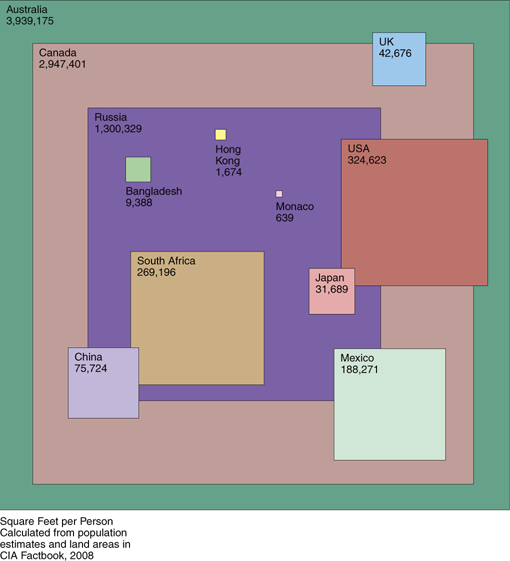
Pretty interesting graphic, no? The boxes refer to the amount of square feet per person in the selected countries. Loads of empty countries there. Of course, you need to know what you are doing with those lands and whether those lands are capable of supporting people (cant see many places in Australia or USSR being very conducive to living comfortably)
Saturday, May 31
Shifting borders and shifting sands
You must have seen this picture many times:
As an amateur historian, I am always curious about the boundaries and how history is framed. For example, the first photo establishes a state called as Palestine in 1946 which sort of puzzled me because there was an Ottoman Empire then and not a country known as Palestine. Mind you, there wasnt a state called as Israel either before 1948! If one thinks about Zionism as a driver, then this should go back to centuries and millennium. But as an ideology, you can go back to 1882 when the immigration started. But the immigration went into the Ottoman Empire and not into a state called as Palestine.
On the other hand, you can then draw the Palestinian parallels to the Philistines. You can also legitimately argue that the Roman state unit called as Palaestina created after they defeated the Jews was one of the ancestors of current day Palestine.
Now if I go back a bit further, you can see where the challenge comes from. Look here at how the Roman Empire grew and shrunk over hundreds of years.
Obviously, the latter part of the presentation talks about the Byzantine empire and how it got taken over by the Ottoman Empire and then the Ottoman Empire then disintegrated into various countries just like the Roman Empire did. Borders shift all the time when seen from a distance. See more here for Ethiopia.
But this was even more interesting, how do you look at the Persian Empire? They also ruled over vast swathes of the Middle East. Did you know, the bastion of Sunni thought, Al Azhar, was actually founded by a Shia empire? Curious, no? Check out the Middle East changes here.
How about the Armenians? See their history here. How about Kosovo? It has had a long history and how there is talk about it seceding from Serbia. And as soon as it does, it will be recognised by the USA and UK. And when it does, a huge spear called as hypocrisy will go through almost every political structure.
If Kosovo can be independent, why cant Palestine be? Or Northern Cyprus? Or Kurdistan in Turkey? Or Eastern Shia in Saudi Arabia? Or Baluchistan in Pakistan? Or Kashmir in India? Or Southern Thailand? Or Darfur from Sudan? The basic principle is the same no?
But over the long view, you can see how boundaries rise and change.
Thursday, April 3
Is it the Arabian Gulf or the Persian Gulf??
For the records, the name Persia has always been used to describe the nation of Iran, its people, and its ancient empires since 600 BC. It is derived from the ancient Greek name for Iran's maritime province, called Fars or Pars in modern Persian, Pars in Middle Persian and Pârsa in Old Persian, a word meaning "above reproach.” Persis is the Hellenized form of Pars, and through the Latinized word Persia, the other European nations came to use this word for the region. This area was the core of the original Persian Empire.
Since ancient times almost all foreigners referred to the entire country
as Persia until March 21, 1935, when Reza Shah Pahlavi formally asked the
international community to call the country Iran — a name that the people of
Persia, themselves, used to refer to their country since the Sassanian period.
"Iran" means "Land of Aryans". In 1959 some Persian scholars protested to the
government that the name change had separated the country from its ancient
civilization. Therefore, the late King Mohammad Reza Shah Pahlavi announced that both Persia and Iran can be used in Western languages.
Without disparaging the Arabs, Iranians are proud of their non-Arab heritage and
strongly resent any attempt at denigrating or changing any aspect of their
Iranian heritage. And the Persian Gulf occupies a pivotal place in the Iranian
history and culture. Furthermore, Iran abuts the Persian Gulf for 2,000 Km,
while about a dozen recently-created Arab Sheikhdoms and emirates border the
Gulf on the other side.
All this to be taken with a grain of piquant salt!!!
Sunday, February 17
Shifting borders and shifting sands
You must have seen this picture many times:
As an amateur historian, I am always curious about the boundaries and how history is framed. For example, the first photo establishes a state called as Palestine in 1946 which sort of puzzled me because there was an Ottoman Empire then and not a country known as Palestine. Mind you, there wasnt a state called as Israel either before 1948! If one thinks about Zionism as a driver, then this should go back to centuries and millennium. But as an ideology, you can go back to 1882 when the immigration started. But the immigration went into the Ottoman Empire and not into a state called as Palestine.
On the other hand, you can then draw the Palestinian parallels to the Philistines. You can also legitimately argue that the Roman state unit called as Palaestina created after they defeated the Jews was one of the ancestors of current day Palestine.
Now if I go back a bit further, you can see where the challenge comes from. Look here at how the Roman Empire grew and shrunk over hundreds of years.
Obviously, the latter part of the presentation talks about the Byzantine empire and how it got taken over by the Ottoman Empire and then the Ottoman Empire then disintegrated into various countries just like the Roman Empire did. Borders shift all the time when seen from a distance. See more here for Ethiopia.
But this was even more interesting, how do you look at the Persian Empire? They also ruled over vast swathes of the Middle East. Did you know, the bastion of Sunni thought, Al Azhar, was actually founded by a Shia empire? Curious, no? Check out the Middle East changes here.
How about the Armenians? See their history here. How about Kosovo? It has had a long history and how there is talk about it seceding from Serbia. And as soon as it does, it will be recognised by the USA and UK. And when it does, a huge spear called as hypocrisy will go through almost every political structure.
If Kosovo can be independent, why cant Palestine be? Or Northern Cyprus? Or Kurdistan in Turkey? Or Eastern Shia in Saudi Arabia? Or Baluchistan in Pakistan? Or Kashmir in India? Or Southern Thailand? Or Darfur from Sudan? The basic principle is the same no?
But over the long view, you can see how boundaries rise and change.